Файл:Earth nospinn.png: различия между версиями
| (не показана 1 промежуточная версия этого же участника) | |||
| Строка 3: | Строка 3: | ||
author: [[Witold Fraczek]] | author: [[Witold Fraczek]] | ||
| − | [http://www.esri.com/news/arcuser/0610/nospin.html ArcGIS was used to perform complex raster analysis and volumetric computations and generate maps that visualize these results... ArcGIS lets us model the effects of this scenario, performing calculations and estimations and creating a series of maps showing the effects the absence of centrifugal force would have on sea level... Given the fixed volume of water in both hemispheres, the more capacious basin of the southern pole would result in an overall lower sea level than the northern ocean. According to volumetric calculation performed with the [[# | + | [http://www.esri.com/news/arcuser/0610/nospin.html ArcGIS was used to perform complex raster analysis and volumetric computations and generate maps that visualize these results... ArcGIS lets us model the effects of this scenario, performing calculations and estimations and creating a series of maps showing the effects the absence of centrifugal force would have on sea level... Given the fixed volume of water in both hemispheres, the more capacious basin of the southern pole would result in an overall lower sea level than the northern ocean. According to volumetric calculation performed with the [[aw:ArcGIS#3D Analyst|ArcGIS 3D Analyst extension]], the difference between the sea level of the two oceans should be 1,407 meters.] |
= Предыдущие модели = | = Предыдущие модели = | ||
[[file:Earth nospinn 2003.png]] | [[file:Earth nospinn 2003.png]] | ||
| − | |||
| − | |||
| − | |||
| − | |||
| − | |||
| − | |||
Текущая версия на 14:21, 29 ноября 2018
from https://gisandscience.com/2009/09/10/what-would-happen-if-the-earth-stopped-spinning/
author: Witold Fraczek
ArcGIS was used to perform complex raster analysis and volumetric computations and generate maps that visualize these results... ArcGIS lets us model the effects of this scenario, performing calculations and estimations and creating a series of maps showing the effects the absence of centrifugal force would have on sea level... Given the fixed volume of water in both hemispheres, the more capacious basin of the southern pole would result in an overall lower sea level than the northern ocean. According to volumetric calculation performed with the ArcGIS 3D Analyst extension, the difference between the sea level of the two oceans should be 1,407 meters.
Предыдущие модели[править]

История файла
Нажмите на дату/время, чтобы просмотреть, как тогда выглядел файл.
| Дата/время | Миниатюра | Размеры | Участник | Примечание | |
|---|---|---|---|---|---|
| текущий | 16:17, 28 ноября 2018 | 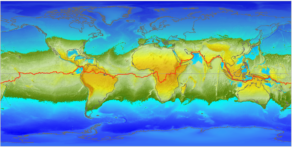 | 1017 × 512 (630 КБ) | It4history (обсуждение | вклад) | from https://gisandscience.files.wordpress.com/2009/09/world_2oceans_1continent_nospinn.png |
- Вы не можете перезаписать этот файл.
Использование файла
Следующие 2 страницы используют данный файл: